Bishopstoke History Society
Changing Eastleigh
(Produced from a presentation compiled by Chris Humby in May 2017)
 (The prototype Spitfire K5054 at Eastleigh, 11th May 1936)
Eastleigh is home to the Spitfire, which first flew from Eastleigh Airfield on 11th May 1936. This iconic aircraft is synonymous with Britain’s fortitude and endeavour to overcome the threat of invasion. Eastleigh airfield and the Cunliffe Owen aircraft factory to the south of the airport, where Spitfires were built, was attacked on a number of occasions during WWII. There was a separate operation at the airfield called HMS Raven. There was a certain amount of mirth when a report on the radio from the German propaganda machine announced that HMS Raven had been sunk. The Daily Echo in December 1944 reported that during WWII “fatal or serious casualties in Eastleigh due to enemy action had been comparatively few”. In total 23 people had been killed and 21 people seriously injured. A total of 18 properties had been destroyed and a further 17 damaged beyond repair. Much of the damage inflicted on the town had been caused by planes crash landing or jettisoning bombs after being damaged by anti-aircraft fire. There were three direct air attacks. On September 1st, 1940, a single plane dropped bombs on Market Street and Chamberlayne Road; On October 8th, 1940, three Junkers dropped 14 high explosive bombs on the centre of the town and then machine gunned the area, whilst the heaviest raid, which inflicted most casualties took place on June 22nd, 1942, when planes targeting Eastleigh, dropped 17 high explosive bombs and numerous incendiaries across the town, causing considerable damage.


Eastleigh Civil Defence control centre was located under Eastleigh Town Hall and was manned continuously by staff from Eastleigh Borough Council throughout WWII. On occasion, when raids on Southampton had been particularly heavy and telephone communications disrupted, this bunker at Eastleigh became a despatch point for ARP messages and a control centre for the Fire and Rescue Service for other areas outside the Borough.

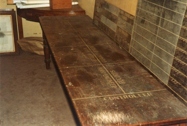


The ARP Controller until early 1943 was Mr. F.G. Lee (Borough Engineer) until he was succeeded by The Town Clerk, Mr J.C. Gardener. These pictures show some of the control boards and Borough records from the 1940s. It is believed that these pictures were taken some time in the 1980s.

Eastleigh, at first site does not appear to have undergone that many changes from the 1960s, although the area we know as Boyatt Wood was just farmland. When you delve into the detail, there have been minor and some major changes, particularly to what were land mark buildings, and we will look at these changes during the course of this article.

These houses stood in Southampton Road, opposite the junction with Derby Road. Today, where these houses stood is a car park, small industrial units, a Texaco garage, and a car sales and hire forecourt.

When this picture was taken you could drive in and out of Grantham Road from Southampton Road opposite the Campbell Road bridge. The pedestrian crossing is still there. The houses on the corner have been demolished and some of the terrace has been demolished and replaced by a Church and a Scout Hall.

Further along Southampton Road was Tolman’s garage in the mid-1960s, now also demolished.

This picture of 132 Southampton Road is on the corner with Blenheim Road and was probably taken in the early 1970s when it was a furniture shop. From 1912 to 1970 it had been a tobacconist and newsagents. Next door at 134 is Cornwell’s betting shop, which was established around 1970. These buildings were demolished to make way for the new Unity Club, which has since been demolished and replaced with flats.

The original Unity club stood on the opposite corner of Blenheim Road and Southampton Road. This is now part of the Swan Centre car park.

Peter Green’s furniture store in Southampton Road. Originally built as a brewery in the 1860s, the site is also now part of the Swan Centre.

Peter Green’s from the corner of Factory Road complete with Triumph Herald. Factory Road is now called Wells Place, this is where the entrance to the Swan Centre car park is off the roundabout, and you no longer see Triumph Herald’s driving around the town.

On the other corner of Factory Road and Southampton Road stood the Beehive Restaurant, run by the Co-Op. This building was taken over by Southern Publicity Ltd by 1970 who operated a printing business from the premises. The building has been demolished and is now the site of the office block on the corner of Wells Place and Southampton Road.

Further along Southampton Road, towards the railway station in the 1950s and 1960s was William Dibben and Sons Ltd, builders’ merchants. The site is now offices and a car park.

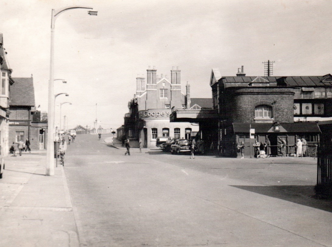
Opposite the railway station from the 1920’s to the early 1970s stood the Station Garage.

This is another view of the Station Garage, with two Cafe’s next door. One was called the Station Café; I can’t remember the name of the other.

The cafés and garage disappeared in the 1970s and, for a while the site became an open air car park.

It has now been replaced by Mitchell House, originally built as offices it has now been converted to flats for residential use.

Eastleigh was not designed with the motor car in mind and there have, over the years, been many schemes developed to try and improve traffic flow. None seem to have been particularly successful. This scheme in the 1970s was not retained for very long. It required all traffic heading north along Southampton Road to turn left into Leigh Road and then right into Upper Market Street if they wished to continue heading to Allbrook or Bishopstoke.

The railway station entrance, in this picture had been created around 1905. Even in the 1960s, on entering the station you had to climb steps to access the booking office, on the first floor. You would then descend to the platform of your destination. The line nearest to Southampton Road, platform 1, was known as the Romsey Line.
The front of Eastleigh Railway Station was also one of the Town Bus Stations. In this picture you can see the wooden waiting room, alongside the area the busses would pull into.

Hants and Dorset busses in the 1950s waiting for passengers at the station. You can see a train standing at platform 1 and the wooden bus waiting room to the left of picture.

Between the station entrance and the Junction Hotel was the railway parcel depot. Small goods were delivered for onward shipment or collected for local distribution from here.

The Junction Hotel, which had once been the home of navvy’s building the railway to Gosport and Salisbury and had hosted many a celebratory meal for attendees of the Bishopstoke Cheese and Livestock Markets had degenerated, by the 1960s, to become an establishment with a reputation for bad behaviour. It was usual at closing time for the police to reverse a police van up to the front door and release police dogs to clear the bar. The licence was revoked, and the building was demolished in the late 1960s. In defence of the Junction Hotel, the regulars did sober up long enough to put on a very good float every year in the Eastleigh Carnival Procession.

The building, centre, is now the entrance to Eastleigh Railway Station. The old entrance and buildings in the foreground have been demolished along with platform 1 and the Romsey line.

The transformation of Eastleigh Railway Station around 1969.

Early 1970s. This layout changed again a few years ago when the station forecourt was re-modelled.

Station Hill in the 1970s looking towards the railway station. Traffic flow was single direction with Upper Market Street and Romsey Road used as a gyratory system. The building next to the bridge, where the Lidl supermarket stands today, was the Railway Civil Engineering Offices and the wagons and sidings were part of Eastleigh Goods yard.

This aerial picture shows the Railway Goods depot in the foreground and the Parish Church on the corner of Twyford Road and Romsey Road. In the distance is the timber yard and builder’s merchants at the end of Toynbee Road, and in the distance, the fields of what is now the Boyatt Wood housing estate.

On the corner of Romsey Road and Station Hill, where the Civic Offices now stand, stood Bakers Coal Services Ltd. There were also Coal Merchants at 4 and 6 Station Hill. Coal Merchants had occupied this corner of Eastleigh from the late 1800s, presumably due to the convenience of this location being opposite the Railway Goods yard and depot where the coal would have arrived by rail.
This entrance to the Railway Goods Depot is now the entrance to the Lidl and Marks and Spencer Food Hall car parks.

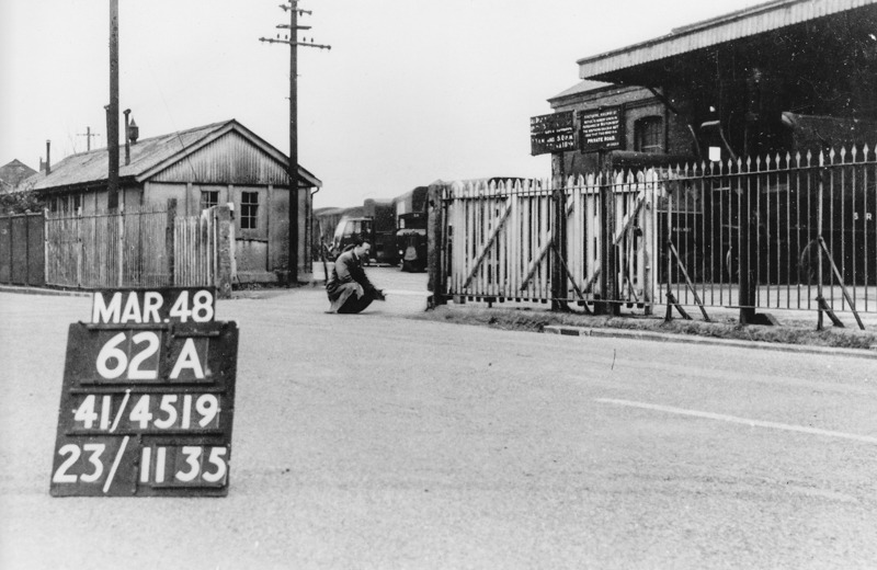
This view of carriage works bridge was taken in 1948. The Railway Civil Engineering Offices, on the left, were demolished in the late 1960s.

The carriage works bridge was not able to support the weight or flow of traffic by the 1970s and, with the railway offices demolished, a Bailey Bridge was erected alongside the existing bridge to enable strengthening to take place. It worked remarkably well. With the new Lidl supermarket in place, it is difficult to see how this bridge will be able to be strengthened and repaired in future without massive diversion and disruption.


These pictures show new services being installed, whilst the picture on the right shows the bridge from ground level, with the Bailey bridge beyond.

This picture appeared in the Southern Daily Echo on Thursday, May 18th, 1972, and explains that traffic will continue to use the old bridge in one direction, whilst the Bailey bridge will take traffic in the other. The article goes on to explain that this arrangement is expected to last three weeks, by which time the Bailey bridge is expected to take two-way traffic.
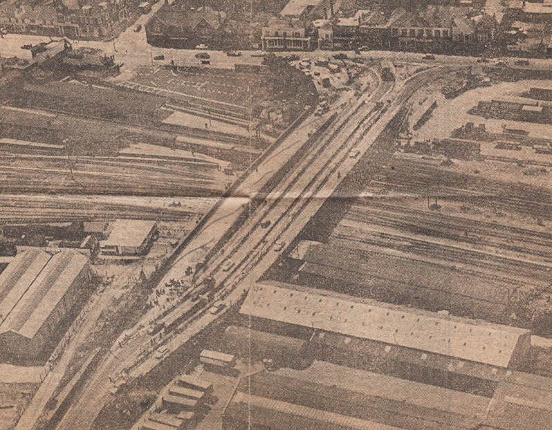
This picture appeared in the Southern Daily Echo on Tuesday July 25th, 1972, and states that the Bailey bridge now takes two-way traffic and in this picture it is shown on the right of the main bridge. The new main bridge is going to cost £366,280 to reconstruct and should be completed by September 1973. The Bailey bridge is in fact two bridges side by side, each 380 feet long, and one bridge includes a 5 ft footpath.

Station Hill has been subject to some change since the 1950s, although some of the original appearance remains. The Crown Hotel was demolished a few years ago and replaced by the Travelodge Hotel, whilst the shops on the right have been replaced by the Women’s Institute Headquarters.

Station Hill as it was in 1948.

This picture of Station Hill from the 1970s is not that different from the appearance today. Some of the names have changed and Eastleigh House has been re-clad and is now the Civic Offices. Wessex House has been built this side of Eastleigh House.

A lost and forgotten area of Eastleigh that was key to life in the 1960s and 1970s was Eastleigh Bus Station. This was located, not in the centre of town, but between Southampton Road and Market Street, south of Blenheim Road, opposite the approach to Campbell Road bridge.

Eastleigh Bus Station was the hub for public transport in the town although there were supplementary bus stations outside the Railway Station and in Upper Market Street.

Space was limited for storage of busses. There was a workshop for maintenance. Busses would enter from Southampton Road and exit into Market Street.

Facilities were upgraded in the 1960s to provide more shelter for waiting passengers. The bus station was popular with students of Wyvern, in Desborough Road and Barton Peveril, in Chestnut Avenue, who had to travel from some of the outlying villages like Colden Common, Fair Oak and Durley.

New to Hants & Dorset in October 1968, this single decker Bristol RE provided seats for 45 passengers. It is seen turning out of the old Eastleigh Bus Station, into Market Street, around 1969 operating on route 41 to Colden Common.

Today the old bus station area has been redeveloped. The bus to Colden Common would have been joining Market Street at this junction. The car park for St Andrew’s Surgery can be seen on the right, whilst the back of St Andrew’s Methodist Church, in Blenheim Road, is on the left.

A major landmark building in Eastleigh from the 1930s through to the 1970s was The Co-op Department Store on the corner of Blenheim Road and High Street.

This is an artist’s impression of how the building was going to look when it was built in the late 1930s.

Only the corner section was constructed in 1937 when this building became the largest shop in Eastleigh.

The rest of the building was not constructed due to financial restrictions after WWII. The smaller shops alongside were owned by the Co-op but continued to operate as specialist units within the society.

In a relatively short time, the landmark retail building in Eastleigh became neglected when this part of the town was earmarked for redevelopment.

This building was demolished to make way for the development of a new Tesco’s supermarket in the 1970s. A memory from the heyday of this shop to me as a young child was the fascinating vacuum suction system which was used to transfer tubular containers of money away from the serving area to a central accounts office which were then returned with the change and a receipt to be handed to the customer.

Although Eastleigh was considered to be a Railway Town, one of the major employers in Eastleigh was Pirelli General Cable Works Ltd in Leigh Road. Established in the 1920s, the site continued to expand into the 1970s.

This picture was probably taken in the 1930s. By the 1960s, when I served my apprenticeship with the company, most of the playing fields and open spaces had been developed as part of the company’s expansion programme.

The main entrance to Pirelli General Cable Works was where the Co-op store in Leigh Road is now located. Those of us who were hourly paid were not allowed to leave the premises without “clocking off”. If we wished to use the canteen there was an entrance from inside the factory where we could eat in an area completely segregated from other staff facilities.
Immediately past the entrance, in Leigh Road, was a door that led to the staff canteen. Only members of staff were permitted to use this facility and once inside you turned right to enter the Monthly paid (executive) dining room or left to enter the segregated Weekly paid staff facility. Working relationships at the time were quite hierarchical, and as hourly paid workers we were discouraged from “mingling” with members of staff in the dining facilities. Certain areas of the factory were also off-limits to hourly paid employees. Thankfully, such attitudes changed during the 1970s and 1980s.

The Good Companions Public House stood next to the Leigh Road entrance. It is still there. The blue door is where the canteen entrance for weekly and monthly paid staff was located, but this picture shows a more interesting feature relating to WWII. As camouflage during the war, the external wall of the Cable Accessories Department, which ran from the entrance to the corner of Dew Lane was disguised as terraced housing, with windows and doors painted on the brickwork to confuse an aerial attack. This camouflage was still evident until the buildings were demolished to make way for new housing development a few years ago.

Befitting such a large organisation, Pirelli had a thriving Sports and Social Club. The Club House is the building with the blue roof in the centre. I remember going to see Adge Cutler and the Wurzels giving a performance here in the early 1970s. Adge had broken his leg in a fall at the Salisbury Playhouse a few weeks earlier and his leg was encased in plaster. He explained that you had to break a leg to get a laugh out of an audience at Salisbury. The large building to the right was the high voltage oil filled cable department, built in the 1960s, and the building to the left was office accommodation built in the 1970s. The area in the foreground was the employee’s car park. Today this is now Tinning Way, opposite what used to be the Fleming Park Sports Centre.
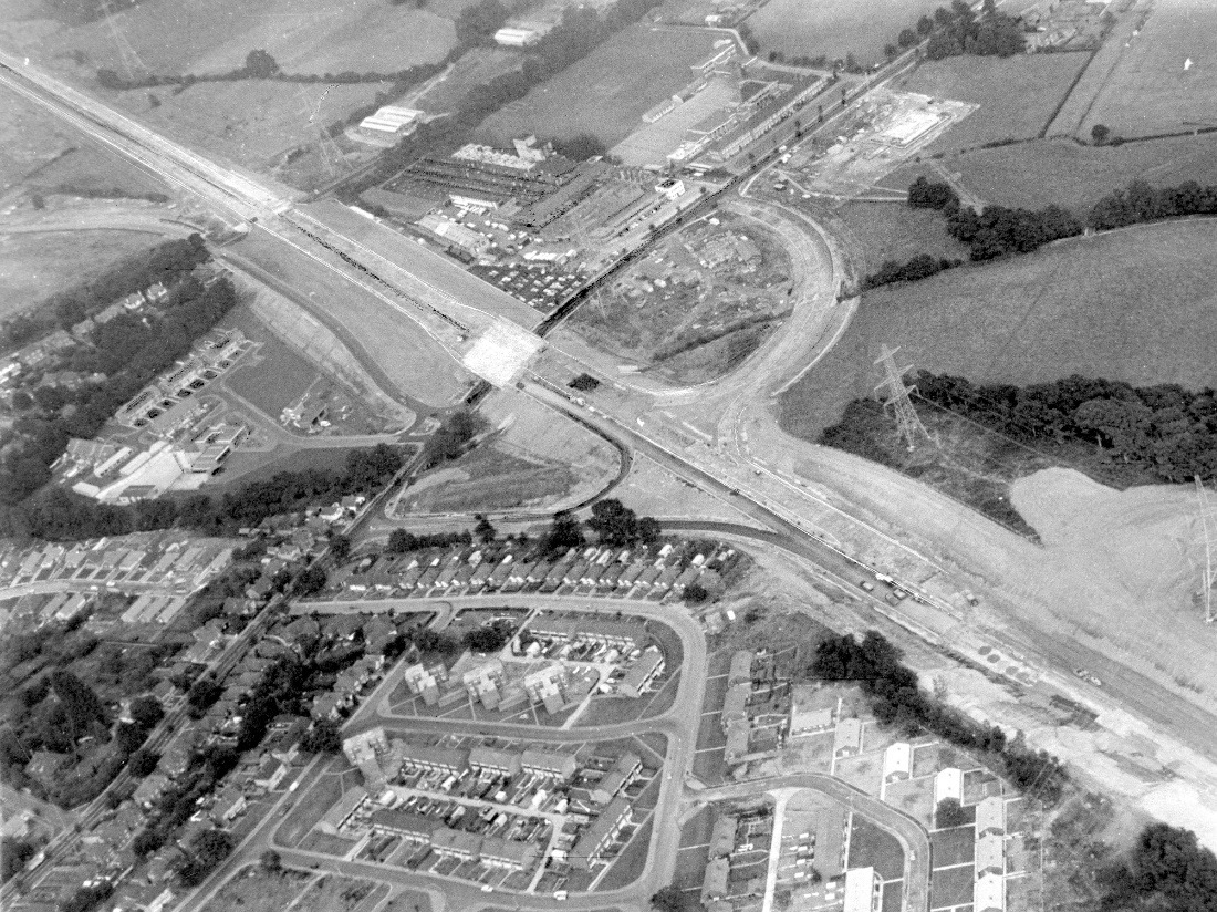
Completed in 1991, the new M3 motorway bisected Eastleigh and Chandler’s Ford. This picture was probably taken mid to late 1980s, you can see preparation taking place to build the new Civic Offices and Law courts in Leigh Road. These have now been demolished to make way for a car sales showroom.

Alongside the motorway in Leigh Road was Price’s (Southern Confectioners) Ltd, built in the late 1930s.


The factory was re-named Manor Bakeries around 1970 and was latterly better known under its trade name, Mr Kipling, until it was closed in 2005.

The name Fleming means very little to the people who live in Eastleigh to-day. The name Fleming derives from the Fleming family who lived at Stoneham Park. The Fleming estate was a great landed estate that existed for over 350 years, from 1599 to the 1950s. In the nineteenth century, John Barton Willis Fleming was one of the largest landed proprietors in Hampshire, the Fleming Estate extending to some 15,000 acres throughout Hampshire and the Isle of Wight. The Estate comprised at least 80 farms in 1872. The majority of the Estate was sold piecemeal at auctions before the First World War and latterly in the 1950s.

The parkland, in Passfield Avenue was purchased by Eastleigh Borough Council in 1929 and designated for recreation facilities. The pavilion in this picture was built together with a rose garden and a fountain.

The pavilion had a pristine appearance when this picture was taken in 1936.

A feature of Fleming Park in the 1960s was the Putting Green and Crazy Golf course. I worked at Barron and Crowther in Woodside Road as a Design Engineer in the early 1970s, where Halfords and Matalan are today. I would often spend lunchtime trying to tackle this course. Probably the reason why I never took up golf.

Another main feature of Fleming Park was the Tennis Courts. Notice how small the car park is and you can also make out the old Leigh Hotel on the left of picture. The original bowling green, putting green and tennis courts now form part of the Holiday Inn, which was originally called the Crest Hotel.

The Fleming Park Pavilion was replaced in the early 1970s.This picture of the new facilities were taken in October 1974 when work was well advanced.

The new Fleming Park Leisure Centre was opened by Mary Peters O.B.E, Olympian, on Friday the 25th of October 1974. To access the Centre, you had to ascend a flight of steps. Alterations in later years made the Centre more inclusive to those with mobility issues.
This Facility has been replaced by a new construction called Places Leisure Eastleigh, and the buildings shown have been demolished.

Another landmark of Eastleigh lost during the 1970s was Hann’s and later Unigate Dairy in Factory Road. It was where the Well’s Place Centre stands today, next to the Swan Centre and is shown towards the top left of this picture.

Where the Well’s Place Centre now stands alongside the Eastleigh Baptist Church was Hann’s Dairy in Factory Road. It had originally been a bacon factory. Opposite, where the small car park is now behind the shops in High Street, was a stable which housed twelve horses and an area which housed carts and horse drawn vans. The business eventually became Brown and Harrison Dairies, then South Coast Dairies and finally Unigate Dairies before the buildings were demolished in the 1980s, as part of the Swan Centre development.

This area of Eastleigh was subject to high activity early in the morning with milk crates being loaded on to the milk floats before the deliveries commenced. By the late 1950s horses had been replaced with electric milk floats.

There was also high activity in the afternoon when the floats and drivers returned from their rounds. The vehicles had to be unloaded and cleaned ready for the next day. I remember when walking past the dairy on the way home from school there was always a strong smell of sour milk when the dairy had been “washed out,” and you had to skip the puddles of rancid milk and water to get past.

Hann’s Dairy was formerly the workplace of Benny Hill and the inspiration for his hit record, Ernie (The fastest milkman in the west). This song topped the charts over Christmas 1971 for four weeks. He is pictured in a horse drawn milk float at the junction of Leigh Road and Southampton Road, opposite the railway station. By 1960, Hann’s Dairies had become Brown and Harrison Dairies.

He really did gallop into Market Street on the way back to the dairy. In this picture it looks like he is getting a ticket for speeding from the local constabulary. I wonder if he used the excuse that he was being chased by scantily clad women which was the scenario used to end many of his T.V. shows.

One of the major landmark buildings in the centre of Eastleigh was the old Lloyd’s Bank building which stood on the corner of Leigh Road and Upper Market Street. It was an attractive feature building that was demolished around 1980 to make way for a new Lloyd’s Bank building.

The new bank building was far larger and offered more accommodating for the needs of modern business. It was constructed around 1982.

The corner of Leigh Road and Upper Market Street was completely transformed in 1982 when the Railway Institute building was demolished. Opened in 1891 this building was used as the meeting rooms for the then Town Council, an education centre for the railway, a social facility for railway employees and the centre for a school which can be linked to the founding of Barton Peveril College. It was the first building in Eastleigh to be connected to electricity for lighting, with a supply connected from the generating plant in Eastleigh Carriage Works.

The old Railway Institute had extensive sports facilities. Behind the building, running part way along Upper Market Street were bowling greens and tennis courts. You can see the roof of the bowling green clubhouse on the right of the picture. There were also a series of bus stops in Upper Market Street and this is where the bus station is today.

This picture, taken in the early 1980s, shows the junction of Leigh Road and Market Street. You can see the new supermarket being built on the old Railway Institute site. In those days Leigh Road was part of a one way system, with traffic able to pass on either side of the bollard in the centre of the road.

The new Safeway supermarket and bus station opened in 1982. This Supermarket is now Sainsbury’s.

In the 1960s Leigh Road was the main road east to west through the town with traffic traveling in both directions. Eastleigh had not been designed for the car and as car ownership became more prevalent, various schemes were adopted to try and better manage vehicle movement. Leigh Road became one way heading west from the station as far as Romsey Road. Upper Market Street became one way between Leigh Road and Romsey Road.

Market Street and High Street were once roads where traffic travelled in either direction. These roads have now been subject to changes in traffic management and became one way traffic flow systems.

On the edge of the Recreation Ground in Leigh Road, opposite the end of High Street was a public shelter with seating on all sides where people could sit and relax. It was known locally as “10 Downing Street” as it was where people would sit and discuss putting the World to rights. The path is still there, but the shelter became much vandalised in the 1960s and was demolished.

The transformation of this part of Eastleigh was completed in 1992, when this section of Leigh Road between Market Street and High Street was pedestrianised.

This picture shows a scene from a Market Day in Eastleigh. The market was held in the car park area behind and alongside the Railway Institute bowling green.

As these pictures illustrate the market was a thriving operation which was held twice a week, although I believe that these particular pictures were taken on a summer bank holiday weekend.

What a difference compared to the handful of stalls that now occupy the pedestrianised precinct on Thursdays and Saturdays.

Although originally built as a residential road, Market Street, along with High Street rapidly developed as the main shopping area of the town. Supermarkets began to appear in the town and, although not the first supermarket in Eastleigh, Fine Fare supermarket replaced the Picture House in the mid-1960s. To-day this is the site of the Superdrug Store.

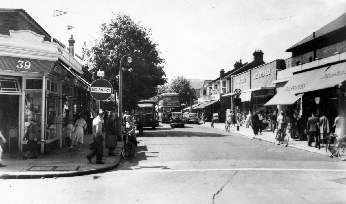
One way traffic systems were introduced in Market Street and High Street during the 1960s. This picture was probably taken in the early 70s and traffic flow in Market Street was the same as it is today.

The Regal Cinema entrance was in the centre and flanked by shops on either side. Boyce Outfitters operated here from 1960 to early 1970s, whilst Maynard’s sweet shop occupied the left hand shop from the late 1930s until the early 1960s. The Regal Cinema was replaced by a nightclub. There have been a number of attempts to operate night clubs from this site for many years, none have been successful.
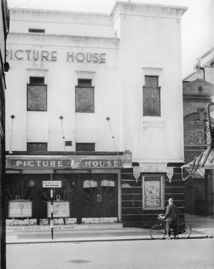
Opposite the Regal Cinema stood the Picture House, another cinema. This closed in the early 1960s when the site was rebuilt for a Fine Fare.
Like Market Street, High Street also become a one way traffic system, but unlike today traffic flowed north from Factory Road towards Leigh Road.

Delbridges, on the corner of High Street and Leigh Road where Kentucky Fried Chicken is today was a very popular shop in the 1960s and 1970s. They sold fruit and vegetables, pet food, animal feed, seeds, garden tools, garden machinery and plants. They were effectively what we know today as a garden centre but located in the centre of the town.

Horace Torbock had run a grocers and provision merchants in Eastleigh since the late 1930s.
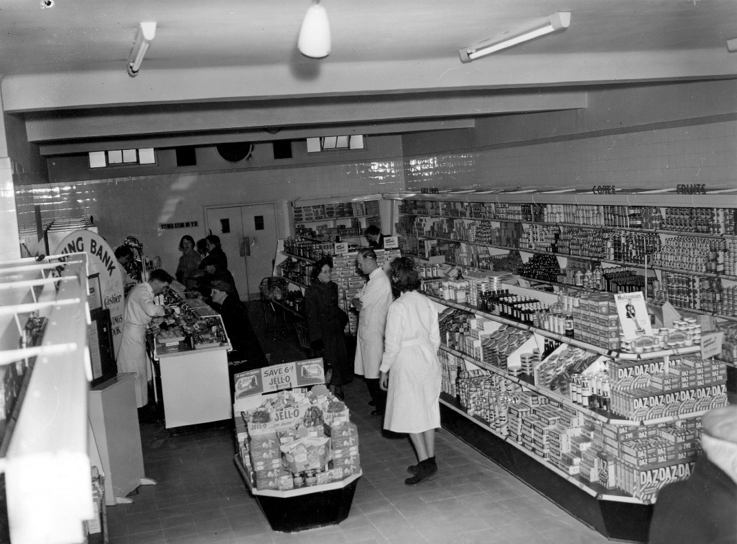
They moved to 26 and 28 High Street, now the site of the Iceland store, and opened the first Supermarket in Eastleigh in April 1954. A newspaper article headed “Food Hygiene at Eastleigh” describes the Torbock Self Service Store in High Street having tiled walls and floor whilst there is a glass front and top to the fats and bacon counter and the well fitted enamel self-service shelves all help Mr Sims, the manager, who can be seen in the centre of the picture talking to a customer, to be able to maintain a really high standard of food cleanliness.

The concept of a self-service supermarket in 1954 was so alien to shoppers that the article went on to explain that this lady is able to choose cake, which, as with all other foods that are pre-packed, are wrapped in cellophane and displayed on the self-service shelves. This was revolutionary and customers needed guidance on how to use the new system. Walking into a shop and taking things off a shelf was alien. It felt like you would be accused of stealing.

Supermarkets did take a while to “catch on” and the centre of Eastleigh continued to be dominated by small family business in the 1960s. This picture was taken on the corner of Market Street and Factory Road. To-day you would be looking towards the Tesco checkout area in the Swan Centre.

This is a picture of Market Street looking north, taken in the late 1960s. Ayley Brothers had run a bicycle dealers here since the mid-1940s. Properties in Market Street and High Street between Blenheim Road and Factory Road became subject to compulsory purchase orders in the late 1960s and this area of Eastleigh became very run down. It was demolished to make way for the development of a new supermarket in the centre of town called Tesco in the early 1970s. This about where the goods vehicle entrance to the Swan Centre is today.

Tesco supermarket was built in the early 1970s and opened in 1973. it was built across Market Street. In this picture you can see the Tesco supermarket under construction and houses and shops that used to stand where the Swan Centre and the Wells Place Centre are today. Some of us rode a bicycle with “Cow Horn” handlebars in the 1960s, like the one pictured in the left foreground of this picture. Oh, if only I had the energy today that I had then.
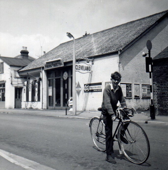
On the opposite side of Factory Road, the dominant building was Young and Beeton’s Garage, who were agents for Renault. Notice the petrol pumps by the pavement. This was typical of garage forecourts in the 1960s. Cars would pull up at the kerb and petrol hoses from the pumps would be pulled across the pavement. Pedestrians would just step over the hose and would probably have also been smoking a cigarette, just to add to the excitement.

Tesco opened in 1973 and was later incorporated into the Swan Centre. There was one unfortunate incident when a motorcycle came down Market Street and crashed through the front doors of the new store. The entrance doors to Tesco were later relocated and the glazing in this section of the building was changed to a more solid appearance.

This is the view looking towards market street from the original Tesco entrance. The new Tesco store was the reason for this part of Market Street to become a one-way traffic system and Market Street was no longer a direct through road.

The impact of creating the new Tesco store should not be underestimated. Not only were many residential and retail outlets demolished, but Market Street was also diverted to allow the development to take place. In this picture you can see the junction of Market Street and Factory Road. A Land Rover is about to exit Market Street adjacent to Allen and Knights on the corner. Market Street has been realigned to run down the side of the new Tesco store.

This new section of Market Street, between Factory Road and Blenheim Road ran close to the back of Peter Green’s furniture store and created an opportunity for a new pedestrian entrance to their furniture and carpet showrooms, which led directly from the main shopping area of Eastleigh.

This is a picture of the car park to the rear of Tesco, with Blenheim Road in the foreground and was taken around 1980. On the far left is E. Lush car sales in what was a service road between Market Street and High Street. Today the road where the garage stood is called Wells Road.

Only a year after opening, the Tesco store in Eastleigh came under pressure from a new “out of town” development. This store at Chandler’s Ford opened in 1974 as Carrefour and was one of the first hypermarkets. I remember at the time it boasted the longest check out aisle of any store in the country. This was reported and featured prominently in national newspapers of the time. It was at the forefront of “out of town” shopping, which catered to the publics new found love of car ownership and motoring. The store created huge interest because not just food but clothes, shoes, toys as well as electrical and household goods were all for sale under one roof. Such was the interest that over 30,000 people arrived at the store on the first day of opening. When this store opened there were no such things as credit cards or bar codes and instead of shelves, items for sale, other than fresh and frozen food, were stacked in cages. This store became Gateway and later Asda.
The hypermarket stands near the site of what in 1937, for a brief period, became the transit camp for refugees from the Spanish Civil War. For a few weeks in the in the summer of 1937, the fields nearby became a tented camp for 4000 children who were aged between 8 and 14, that had been separated from their parents and homeland, and arrived at Southampton Docks by boat, accompanied by only a few teachers from the Basque region of Spain. They were temporarily housed in tents before being processed and distributed to more permanent accommodation throughout the country. They must have felt traumatised by the whole experience. It must have been bad enough to escape war ravaged Spain with the knowledge that you may not see your parents again, but to have to endure British food and a British summer must have been far too much for the children to endure.

Faced by increasing competition from “out of town” shopping centres, like Carrefour, and the development of the M3 and M27 motorways, with easy access to major retail parks at Hedge End and Fareham, Eastleigh town centre retail business started to suffer through loss of custom. A bold plan was developed in the 1980s to try and bring business back to the town of Eastleigh. The intention was to create a two centre retail area for the town. The traditional shopping area of Leigh Road would become pedestrianised between Market Street and High Street and give good access to the new supermarket and Bus Station in Upper Market Street, as well as giving unrestricted pedestrian access to one of the major stores in the town, Woolworth’s. This pedestrianised area was also designated to become an extension of the once popular, twice weekly market, to encourage more footfall.

A new retail development area was outlined for the area south of Factory Road and the block of housing and shops between Southampton Road, Factory Road, High Street and Blenheim Road were demolished to make way for a new retail centre. The relatively new Tesco store was built around, and the intention was to create another magnet area that would link pedestrians to older retail outlets in Market Street and High Street and create two prime shopping areas in the town. This was intended to create a greater movement of shoppers along Market Street and High Street to help support the older traditional establishments.

This picture was taken in 1988. This is the Factory Road frontage, which was re-named ‘Wells Place’ soon afterwards. The Tesco store remained open during construction of the Swan Centre.

The Swan Shopping centre was opened in 1989, a year later than originally planned after a number of significant delays. About 18,000 shoppers visited the Swan Centre during the first two days it was open, half the number that had visited Carrefour, when it opened, on a single day at Chandler’s Ford some 15 years earlier. The Swan Centre now houses the town’s Library and Registrar’s Office which used to be located in the Town Hall. The old Town Hall has been re-named “The Point” and now houses a theatre and dance studio for contemporary performance and dance.
According to Eastleigh Borough Council’s publicity for the town, over the years the Swan Centre has had many famous visitors including Katy Price, the Teenage Ninja Turtles, the England goalkeeper Peter Shilton, and the Daleks. (Form you own opinion as to the high profile of these particular luminaries). Despite good intentions, the Swan Centre failed to attract the major magnet store that the design envisaged. An upgrade in the 2000s created a Cinema, a Bowling Alley, and restaurants above what was originally the ground level car park adjacent to the shopping centre. For a building around 30 years old and intended as a flagship site, the Swan Centre is beginning to show signs of deterioration. The Swan Centre is also suffering from changing trends in retailing.
The introduction of internet shopping has developed rapidly. Over Xmas 2016, online sales were in the order of 40% of all retail sales in the UK. This put pressure on the traditional form of town centre trading. Online trading and home delivery during the pandemic period of 2020 saw online sales increase massively, particularly for food items. Since the 1960s, Eastleigh has lost much of its traditional employment and skills base and many residents, which were once employed locally now commute considerable distance for employment. As a town, Eastleigh is not dissimilar to other communities facing the challenges of the 21st century. Where there were once small family businesses providing a local service, Eastleigh is now served by a plethora of fast food outlets, restaurants, coffee shops, estate agents, pawn shops, mobile phone shops, charity shops and hairdressers and even the once vibrant market has been reduced to a handful of stalls. What developments will take place in the next forty or fifty years? Only time will tell.
Bibliography
Cox, Gordon Daubney (2005), Around Eastleigh, The Francis Frith Collection.
Legg, Penny (2012), Eastleigh – Then and Now, The History Press.
The Eastleigh Photograph Archive, Basque Children .org,
Additional Material
Bob Winkworth, Rod and Joan Simmonds, Roy Smith, Donna Fincher, Linda and Jim Wilkinson, Christine and Nigel Gray, Barry Kitchen, Eastleigh Borough Council, Eastleigh & District Local History Society.